If your own mother does not read your blog, you know it’s time to pack it in. Fortunately, my dear mom is a faithful reader. She works in the geriatric care management industry – basically coordinating medical care for elderly patients – and asked me if I could put together some visualizations of old age in America. I thought it would be a good idea to start with figuring out where exactly older Americans live. This turned out to be a good chance to play with CartoDB and US Census Data. See the end of the post for more details on how I put these maps together, and click on the map images to access the zoomable, clickable CartoDB versions. So here you go mom, this one’s for you.
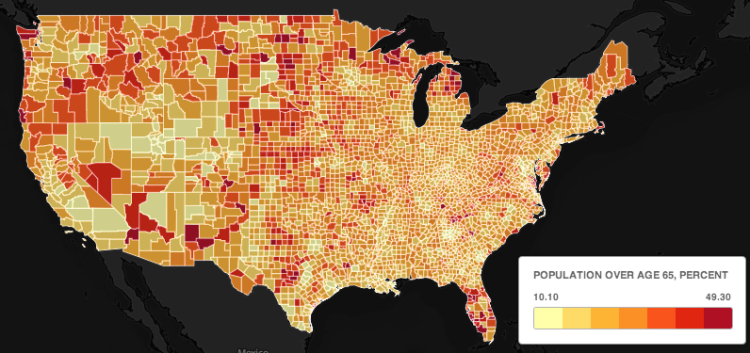
About 14 percent of Americans are over age 65. But, as you can see from the map above, they are not evenly distributed across the county. At the county level the percent of residents over 65 varies from 10 percent to almost 50 percent. You can see that the Great Plains, parts of the west, northern Michigan and Wisconsin, and Florida all have concentrations of these older counties.
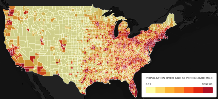
But if we are interested in where the most elderly people live, the percentage of population over 65 is really not the most instructive. After all, many of the counties with high proportions of elderly people are rural counties with low population densities. A more instructive metric would be the number of people over 65 per county per square mile, or the population density of elderly. We can get this by multiplying, in each county, the percent of people over 65 by the total population density. That’s what the map above shows. It looks a lot different than the map of elderly population by percent. You can see that even though areas like the northeast corridor (Washington DC – Boston) do not have an especially large share of elderly residents, the elderly population density is high simply because the total population density is high. Perhaps the most obvious conclusion we can draw from this map is that there are an awful lot of elderly people in the state of Florida.
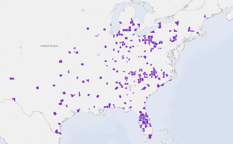
Finally, as an illustration of the sort of things you can do with CartoDB, I made a map (above) that shows counties with relatively high densities of elderly residents and below average median household incomes (click on the image and zoom in to see the smaller urban counties). This might be useful if you were interested in areas where social services for the elderly might be best directed.
Technical Notes: Finally, just a word or two about how I made these maps. First, I downloaded data from the U.S. Census QuickFacts service. With these data you can produce an Excel spreadsheet with county-level attributes on demographics, race, poverty and incomes, and business. I generated another column of population density of residents over 65. Next, I downloaded a shapefile of U.S. counties with state and county FIPS codes. I uploaded both of these into CartoDB and joined the tables by matching the numeric FIPS codes. Finally, I used CartoDBs widgets and filters to produce the chloropleth maps above. To see the maps in CartoDB, click on the images. Click on individual counties to see selected demographic and economic attributes for that county.


It would also be useful to know where the population of elderly who have high incomes reside. Private business, rather than social service organizations, would like to know where people who can pay for higher end service is possible.
I made this map – http://cdb.io/1c7JjLe – of counties with more than 99 people over age 65 per square mile and median household incomes over $70,000. What you basically get is rich suburban counties around the northeast corridor, Chicago/Milwaukee (e.g. Waukesha County, WI and Lake County, IL), and San Francisco and LA. I think to really get information useful to businesses or social services you’d need to look closer – at cities or individual census tracks. There is just too much variation at the county level. For example, no Florida counties fit the criteria of this map because median incomes for the counties are too low. But we know there are many wealthy retirement communities there.
Very Interesting. Thanks, Ken. I am puzzled about FLA. Do you think it could be because of dual residency?
Interesting. I found a typo – “We can get this my multiplying, in each county, the percent of people over 65 by the total population density.” 🙂
thanks!
Well the question I asked was where the least amount a senior citizens live in the u.s. do you have any answer for that or can you get close what city if you can find that thank you