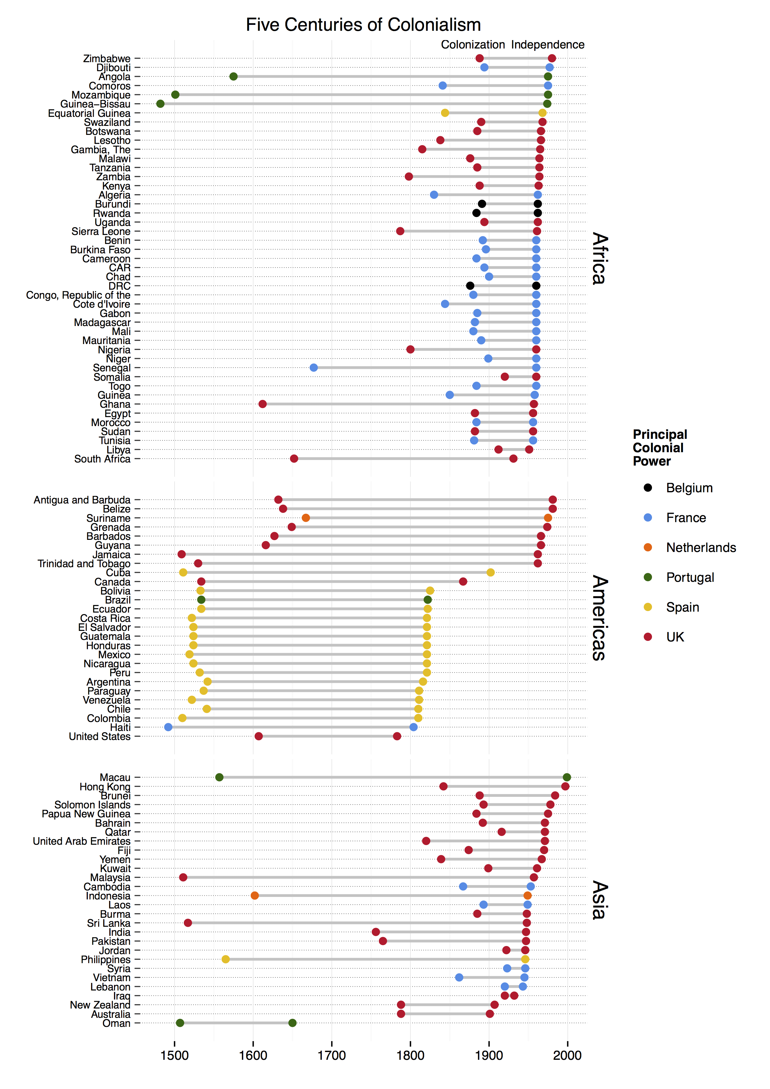
|
Algeria |
1830 |
1962 |
Africa |
France |
5 July 1962 (from France) |
Conquest of Algiers |
|
Angola |
1575 |
1975 |
Africa |
Portugal |
11 November 1975 (from Portugal) |
|
|
Antigua and Barbuda |
1632 |
1981 |
Americas |
UK |
1 November 1981 (from the UK) |
|
|
Argentina |
1542 |
1816 |
Americas |
Spain |
9 July 1816 (from Spain) |
Viceroyalty of Peru |
|
Australia |
1788 |
1901 |
Asia |
UK |
1 January 1901 (from the federation of UK colonies) |
Australia Day |
|
Bahrain |
1892 |
1971 |
Asia |
UK |
15 August 1971 (from the UK) |
|
|
Barbados |
1627 |
1966 |
Americas |
UK |
30 November 1966 (from the UK) |
|
|
Belize |
1638 |
1981 |
Americas |
UK |
21 September 1981 (from the UK) |
|
|
Benin |
1892 |
1960 |
Africa |
France |
1 August 1960 (from France) |
|
|
Bolivia |
1533 |
1825 |
Americas |
Spain |
6 August 1825 (from Spain) |
Conquest of Inca Empire |
|
Botswana |
1885 |
1966 |
Africa |
UK |
30 September 1966 (from the UK) |
|
|
Brazil |
1534 |
1822 |
Americas |
Portugal |
7 September 1822 (from Portugal) |
Captaincies of Brazil |
|
Brunei |
1888 |
1984 |
Asia |
UK |
1 January 1984 (from the UK) |
Treaty of Protection |
|
Burkina Faso |
1896 |
1960 |
Africa |
France |
5 August 1960 (from France) |
Become French Protectorate |
|
Burma |
1885 |
1948 |
Asia |
UK |
4 January 1948 (from the UK) |
Annexed after Third Anglo-British War |
|
Burundi |
1891 |
1962 |
Africa |
Belgium |
1 July 1962 (from UN trusteeship under Belgian administration) |
Originally part of German East Africa |
|
Cambodia |
1867 |
1953 |
Asia |
France |
9 November 1953 (from France) |
Originally claimed by Germany |
|
Cameroon |
1884 |
1960 |
Africa |
France |
1 January 1960 (from French-administered UN trusteeship) |
|
|
Canada |
1534 |
1867 |
Americas |
UK |
1 July 1867 (union of British North American colonies); 11 December 1931 (recognized by UK per Statute of Westminster) |
New France |
|
CAR |
1894 |
1960 |
Africa |
France |
13 August 1960 (from France) |
Ubangi-Shari |
|
Chad |
1900 |
1960 |
Africa |
France |
11 August 1960 (from France) |
Territoire Militaire des Pays et Protectorats du Tchad� |
|
Chile |
1541 |
1810 |
Americas |
Spain |
18 September 1810 (from Spain) |
Santiago founded |
|
Colombia |
1510 |
1810 |
Americas |
Spain |
20 July 1810 (from Spain) |
Founding of Santa Mar�a la Antigua del Dari_n |
|
Comoros |
1841 |
1975 |
Africa |
France |
6 July 1975 (from France) |
|
|
DRC |
1876 |
1960 |
Africa |
Belgium |
30 June 1960 (from Belgium) |
Stanley's first exploration of the Congo |
|
Congo, Republic of the |
1880 |
1960 |
Africa |
France |
15 August 1960 (from France) |
Treaty with de Brazza |
|
Costa Rica |
1522 |
1821 |
Americas |
Spain |
15 September 1821 (from Spain) |
Arrival of Gil Gonzolez Davila |
|
Cote d'Ivoire |
1844 |
1960 |
Africa |
France |
7 August 1960 (from France) |
Establishment of French Protectorate |
|
Cuba |
1511 |
1902 |
Americas |
Spain |
20 May 1902 (from Spain 10 December 1898; administered by the US from 1898 to 1902); not acknowledged by the Cuban Government as a day of independence |
First Spanish Settlement |
|
Djibouti |
1894 |
1977 |
Africa |
France |
27 June 1977 (from France) |
French Somalialand |
|
Ecuador |
1534 |
1822 |
Americas |
Spain |
24 May 1822 (from Spain) |
Conquest of Sebasti�n de Benalc�zar |
|
Egypt |
1882 |
1956 |
Africa |
UK |
28 February 1922 (from UK protectorate status; the revolution that began on 23 July 1952 led to a republic being declared on 18 June 1953 and all British troops withdrawn on 18 June 1956); note – it was ca. 3200 B.C. that the Two Lands of Upper (southern) and Lower (northern) Egypt were first united politically |
British occupation |
|
El Salvador |
1524 |
1821 |
Americas |
Spain |
15 September 1821 (from Spain) |
Conquest by Pedro de Alvarado |
|
Equatorial Guinea |
1844 |
1968 |
Africa |
Spain |
12 October 1968 (from Spain) |
Territorios Espa_oles del Golfo de Guinea |
|
Fiji |
1874 |
1970 |
Asia |
UK |
10 October 1970 (from the UK) |
British subjugation |
|
Gabon |
1885 |
1960 |
Africa |
France |
17 August 1960 (from France) |
Occupied by France |
|
Gambia, The |
1815 |
1965 |
Africa |
UK |
18 February 1965 (from the UK) |
British presence established |
|
Ghana |
1612 |
1957 |
Africa |
UK |
6 March 1957 (from the UK) |
Gold coast forts |
|
Grenada |
1649 |
1974 |
Americas |
UK |
7 February 1974 (from the UK) |
French found permanent settlement |
|
Guatemala |
1524 |
1821 |
Americas |
Spain |
15 September 1821 (from Spain) |
Conquest by Pedro de Alvarado |
|
Guinea-Bissau |
1482 |
1974 |
Africa |
Portugal |
24 September 1973 (declared); 10 September 1974 (from Portugal) |
Portuguese gold coast colony |
|
Guinea |
1850 |
1958 |
Africa |
France |
2 October 1958 (from France) |
French military penetration in the mid-19th century |
|
Guyana |
1616 |
1966 |
Americas |
UK |
26 May 1966 (from the UK) |
Essequebo colony (Durch) |
|
Haiti |
1492 |
1804 |
Americas |
France |
1 January 1804 (from France) |
Columbus found La Navidad |
|
Honduras |
1524 |
1821 |
Americas |
Spain |
15 September 1821 (from Spain) |
Conquest of Gil Gonz�lez de �vila |
|
Hong Kong |
1842 |
1997 |
Asia |
UK |
none (special administrative region of China) |
Treaty of Nanking |
|
India |
1756 |
1947 |
Asia |
UK |
15 August 1947 (from the UK) |
Company rule by East India Company begins |
|
Indonesia |
1602 |
1949 |
Asia |
Netherlands |
17 August 1945 (declared) |
Dutch East India Company Established in 1602 |
|
Iraq |
1920 |
1932 |
Asia |
UK |
3 October 1932 (from League of Nations mandate under British administration); note – on 28 June 2004 the Coalition Provisional Authority transferred sovereignty to the Iraqi Interim Government |
League of Nations mandate under British administration |
|
Jamaica |
1509 |
1962 |
Americas |
UK |
6 August 1962 (from the UK) |
First Spanish settlement |
|
Jordan |
1922 |
1946 |
Asia |
UK |
25 May 1946 (from League of Nations mandate under British administration) |
League of Nations mandate under British administration |
|
Kenya |
1888 |
1963 |
Africa |
UK |
12 December 1963 (from the UK) |
Imperial British East Africa Company |
|
Kuwait |
1899 |
1961 |
Asia |
UK |
19 June 1961 (from the UK) |
British protectorate |
|
Laos |
1893 |
1949 |
Asia |
France |
19 July 1949 (from France) |
French protectorate of Laos |
|
Lebanon |
1920 |
1943 |
Asia |
France |
22 November 1943 (from League of Nations mandate under French administration) |
League of Nations mandate under French administration |
|
Lesotho |
1838 |
1966 |
Africa |
UK |
4 October 1966 (from the UK) |
arrival of Trekboers |
|
Libya |
1912 |
1951 |
Africa |
UK |
24 December 1951 (from UN trusteeship) |
Italian North Africa |
|
Macau |
1557 |
1999 |
Asia |
Portugal |
none (special administrative region of China) |
Portugal settlement |
|
Madagascar |
1882 |
1960 |
Africa |
France |
26 June 1960 (from France) |
Malagasy Protectorate |
|
Malawi |
1876 |
1964 |
Africa |
UK |
6 July 1964 (from the UK) |
Trading settlement at Blantyre |
|
Malaysia |
1511 |
1957 |
Asia |
UK |
31 August 1957 (from the UK) |
Portuguese Malacca |
|
Mali |
1880 |
1960 |
Africa |
France |
22 September 1960 (from France) |
French Sudan |
|
Mauritania |
1890 |
1960 |
Africa |
France |
28 November 1960 (from France) |
Approximate |
|
Mexico |
1519 |
1821 |
Americas |
Spain |
16 September 1810 (declared); 27 September 1821 (recognized by Spain) |
Spanish conquest |
|
Morocco |
1884 |
1956 |
Africa |
France |
2 March 1956 (from France) |
First Spanish protectorate |
|
Mozambique |
1501 |
1975 |
Africa |
Portugal |
25 June 1975 (from Portugal) |
Captaincy of Sofala |
|
New Zealand |
1788 |
1907 |
Asia |
UK |
26 September 1907 (from the UK) |
Colony of New South Wales |
|
Nicaragua |
1524 |
1821 |
Americas |
Spain |
15 September 1821 (from Spain) |
First Spanish settlements |
|
Nigeria |
1800 |
1960 |
Africa |
UK |
1 October 1960 (from the UK) |
|
|
Niger |
1899 |
1960 |
Africa |
France |
3 August 1960 (from France) |
Vouley Chanoine Mission |
|
Oman |
1507 |
1650 |
Asia |
Portugal |
1650 (expulsion of the Portuguese) |
Occupation of Muscat |
|
Pakistan |
1765 |
1947 |
Asia |
UK |
14 August 1947 (from British India) |
Start of company rule in Indian subcontinent |
|
Papua New Guinea |
1884 |
1975 |
Asia |
UK |
16 September 1975 (from the Australian-administered UN trusteeship) |
German New Guinea |
|
Paraguay |
1537 |
1811 |
Americas |
Spain |
14 May 1811 (from Spain) |
Founding of Asuncion |
|
Peru |
1532 |
1821 |
Americas |
Spain |
28 July 1821 (from Spain) |
Battle of Cajamarca |
|
Philippines |
1565 |
1946 |
Asia |
Spain |
4 July 1946 (from the US) |
Miguel Lopez de Legazpi arrives |
|
Qatar |
1916 |
1971 |
Asia |
UK |
3 September 1971 (from the UK) |
British protectorate |
|
Rwanda |
1884 |
1962 |
Africa |
Belgium |
1 July 1962 (from Belgium-administered UN trusteeship) |
Assigned to German East Africa |
|
Senegal |
1677 |
1960 |
Africa |
France |
4 April 1960 (from France); note – complete independence achieved upon dissolution of federation with Mali on 20 August 1960 |
French control |
|
Sierra Leone |
1787 |
1961 |
Africa |
UK |
27 April 1961 (from the UK) |
"Province of Freedom" |
|
Solomon Islands |
1893 |
1978 |
Asia |
UK |
7 July 1978 (from the UK) |
British protectorate |
|
Somalia |
1920 |
1960 |
Africa |
UK |
1 July 1960 (from a merger of British Somaliland that became independent from the UK on 26 June 1960 and Italian Somaliland that became independent from the Italian-administered UN trusteeship on 1 July 1960 to form the Somali Republic) |
Dervish state falls |
|
South Africa |
1652 |
1931 |
Africa |
UK |
31 May 1910 (Union of South Africa formed from four British colonies: Cape Colony, Natal, Transvaal, and Orange Free State); 31 May 1961 (republic declared); 27 April 1994 (majority rule) |
Cape Town founded |
|
Sri Lanka |
1517 |
1948 |
Asia |
UK |
4 February 1948 (from the UK) |
Portuguese establish Colombo |
|
Sudan |
1882 |
1956 |
Africa |
UK |
1 January 1956 (from Egypt and the UK) |
British Occupation |
|
Suriname |
1667 |
1975 |
Americas |
Netherlands |
25 November 1975 (from the Netherlands) |
Capture by Dutch |
|
Swaziland |
1890 |
1968 |
Africa |
UK |
6 September 1968 (from the UK) |
British, Dutch, Swazi trimviral administration |
|
Syria |
1923 |
1946 |
Asia |
France |
17 April 1946 (from League of Nations mandate under French administration) |
League of Nations mandate under French administration |
|
Tanzania |
1885 |
1964 |
Africa |
UK |
26 April 1964; Tanganyika became independent on 9 December 1961 (from UK-administered UN trusteeship); Zanzibar became independent on 10 December 1963 (from UK); Tanganyika united with Zanzibar on 26 April 1964 to form the United Republic of Tanganyika and Zanzibar; renamed United Republic of Tanzania on 29 October 1964 |
German East Africa (Zanibar controled by Portuguese in 16th century |
|
Togo |
1884 |
1960 |
Africa |
France |
27 April 1960 (from French-administered UN trusteeship) |
German Protectorate |
|
Trinidad and Tobago |
1530 |
1962 |
Americas |
UK |
31 August 1962 (from the UK) |
Spanish settlement |
|
Tunisia |
1881 |
1956 |
Africa |
France |
20 March 1956 (from France) |
French Invasion |
|
Uganda |
1894 |
1962 |
Africa |
UK |
9 October 1962 (from the UK) |
Uganda Protectorate |
|
United Arab Emirates |
1820 |
1971 |
Asia |
UK |
2 December 1971 (from the UK) |
Trucial States |
|
United States |
1607 |
1783 |
Americas |
UK |
4 July 1776 (declared); 3 September 1783 (recognized by Great Britain) |
Jamestown |
|
Venezuela |
1522 |
1811 |
Americas |
Spain |
5 July 1811 (from Spain) |
Settlement of Cumana |
|
Vietnam |
1862 |
1945 |
Asia |
France |
2 September 1945 (from France) |
Cochinchina |
|
Yemen |
1839 |
1967 |
Asia |
UK |
22 May 1990 (Republic of Yemen was established with the merger of the Yemen Arab Republic [Yemen (Sanaa) or North Yemen] and the Marxist-dominated People's Democratic Republic of Yemen [Yemen (Aden) or South Yemen]); note – previously North Yemen became independent in November 1918 (from the Ottoman Empire) and became a republic with the overthrow of the theocratic Imamate in 1962; South Yemen became independent on 30 November 1967 (from the UK) |
British occupy Aden |
|
Zambia |
1798 |
1964 |
Africa |
UK |
24 October 1964 (from the UK) |
Claimed by Portugal |
|
Zimbabwe |
1888 |
1980 |
Africa |
UK |
18 April 1980 (from the UK) |
British South Africa Company |